Thursday, 27 February 2020

A Magical Walk Along the Gover Valley, St.Austell, Cornwall

Gover Valley, St.Austell, Cornwall

It was a dull day, drizzly at times, but I decided to take a wander along the Gover Valley in St.Austell. I have previously published a post, with 33 photos, of a walk based on the valley - there's a link at the end of this post.

Gover Valley daffodils, Cornwall

A few daffodils brightened the day as did the Gover Stream, which feeds into the St.Austell River, as it is called locally, but is shown on maps as the River Vinnick.

Gover Stream, Gover Valley, Cornwall

Another name often used for the stream is the White River, because it can become coloured by local china clay.

Gover Valley, Cornwall, old buildings

Along the Gover Valley are remnants left over from the china clay industry.

Gover Valley, river, trees and moss.

Alongside the river is the occasional house, like this one, almost hidden amongst the trees.

House hidden away in Gover Valley, Cornwall

Being a valley it is often shaded from the sun so can be quite damp. 

Stream in Gover Valley, Cornwall

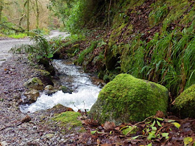
The dampness encourages mosses to grow by the Gover Stream.

Stream in Gover Valley, St.Austell Cornwall

The moss, combined with the tinkling water, can create a magical moment. It's easy to think of this as a home for the elves and fairies - or perhaps that's just my imagination.


But, whatever, the greenness that abounds at this time of year has an attractive quality.

Stream in Gover Valley, St.Austell, Cornwall

A Public Footpath sign shows a way up the side of the valley for those so inclined.

Public Footpath and bridge in Gover Valley, St.Austell, Cornwall

There's a bridge over the stream and a few steps have been made to assist the little people and us humans on their way.

Footpath and steps in Gover Valley, Cornwall

I chose to continue walking along the valley itself, some gorse made a change from the greenness, it seemed to bring everything more alive.

Yellow gorse in Gover Valley, Cornwall

On my return along the valley an old gate was struggling to protect access to an open field.

Gate, Gover Road, St.Austell, Cornwall

Delicate colour with a few primroses nestled by the edge of the road, next to a puddle from the drizzle.

Primroses on the road side in Gover rd., St.Austell, Cornwall

Then all at once I saw a crowd,
A host of golden daffodils.


Please also see:
33 Photos: A Circular Walk Based On Gover Valley, St.Austell, Cornwall

Monday, 24 February 2020

14 Photos of DuPorth Beach, Cornwall


Following on from previous posts mentioning Duporth Beach today we are actually on the beach - and what's more the sun is shining. Pretty good for February.


Duporth means two coves in the Cornish language. On some older maps it is shown as Du Porth.


Access to the beach is only via the South West Coast Path. There are steps down from the path. The beach is backed by high cliffs. 

The photos above and below show water running down the cliffs. You may be able to see a light coloured rainbow as the sun shines on the water in the photo below.


It has to be mentioned that the cliffs are subject to rock falls - see the sign below.


Lots of rocks on the beach.


The cliffs are higher at the far end of the beach.


More rocks.


Interesting how the rocks vary - well, at least it is for me.


Looking up at the far end of the beach a tree balances precariously on the edge.


Rocks of all sorts reaching the water.


Looking back along the beach


For most of the time we were the only two people on the beach, but two men and a woman arrived walking with their dogs.

There are a few houses on the top of the cliffs. The coastal path passes in front of the houses along the cliff tops.


Back to the steps leading down from the coastal path.

Note that there aren't any facilities, toilets etc. on the beach - and there isn't a car park. This means the beach doesn't get overcrowded.


See also: Walking From Porthpean Beach to Duporth and Charlestown, Cornwall - Part 1

Friday, 21 February 2020

On Tour: Visiting Glastonbury Abbey, Glastonbury Tor and King Arthur


I know that this blog is titled Mike's Cornwall but at times I do travel further than my home county. So I thought I would occasionally write posts on interesting places I visit. Today that is Glastonbury, I guess this is about 130 miles from Cornwall. So not too far from home.


I find Glastonbury a fascinating place as it has links to the legendry King Arthur - as does Cornwall.

The first two photos show what is left of Glastonbury Abbey. It's still an interesting place to visit and the grounds of the Abbey are very attractive - and, what's more, there is a connection to King Arthur. He may have once been buried here. 

There is a sign, as below, which reads: Site of the ancient graveyard where in 1191 the monks dug to find the tombs of Arthur and Guinevere.


There is yet another sign stating: Site of King Arthur's Tomb. In the year 1191 the bodies of King Arthur and his Queen were said to have been found on the south side of the Lady Chapel.

On 19th of April 1278 their remains were removed in the presence of King Edward I and Queen Eleanor to a black marble tomb on this site. This tomb survived until the dissolution of the abbey in 1539.

So there we have it King Arthur was buried here and, as we know, he was supposedly born in Tintagel Castle, Cornwall - well so the story goes.


Judging by the remains of the Abbey it would have once been quite a wonderfully ornate building.


What does remain intact is The Abbot's Kitchen said to be one of the best preserved medieval kitchens in Europe.

The kitchen was built in the 1300s to provide meals for the abbot and his guests. As head of the richest monastery in England, after Westminster, the abbot lived and dined in great splendour.


The monks had their own kitchen and dining room. Their diet though was plain and the eating of meat was restricted. The abbots food was far more elaborate.


I came across the very old picture below which showed the Abbey and grounds as it was in the 1300s.

On the picture 1 is the Abbey, 2 is the Abbots Kitchen and 3 is Glastonbury Tor.

Moving on to Glastonbury Tor, this can be seen from the Abbey grounds.


Below is Glastonbury Tor close up. It's a bit of a climb to reach but not too difficult. There are some lovely views from the top. Weather permitting it's possible to see three counties: Somerset, Dorset and Wiltshire.


For many the Tor is a sacred pilgrimage. There are various legends to the area often mentioning King Arthur and Avalon. Some believe that the Holy Grail is buried somewhere on the Tor.

The word Tor has a Celtic origin meaning hill. The conical nature of Glastonbury Tor is natural. It is made up of horizontal bands of clays and limestone with a cap of hard sandstone.


At the top of the Tor is St. Michael's Tower, part of a church which was destroyed by an earthquake in 1275.

The last abbot of Glastonbury Abbey was Richard Whiting, sometimes shown as Whyting. He was hanged, drawn and quartered as a traitor on Glastonbury Tor in 1539.


So there we go, many interesting places to visit besides Cornwall, but I'm always happy  to return home.

Tuesday, 18 February 2020

A Flavour Of the Old Town of Fowey, Cornwall With 24 Photos


Esplanade, Fowey, Cornwall
A dull day but we had a walk along the Esplanade in Fowey and then into the town.

There are pleasant
views from the Esplanade, as it's quite high and looks across the Fowey River.

River Fowey lokking down from on high

Some of the homes on the edge have a distinct style. Below is The Crab Pot.

The Crab Pot House, Fowey, Cornwall

On the opposite side of the River Fowey is the lovely village of Polruan.

Village of Polruan, Cornwall

The house below, one of a terrace, has views of the river - as can be seen by looking through the window!

House on riversaide at Fowey Cornwall

At the end of the Esplanade we turn right and head into Fowey town. A little damp underfoot because of a fine drizzle!

Fowey, Cornwall, Shops

We soon reach the quayside. Looks so different in the sunshine months when the trees are full of leaves - and there are people strolling about.

Cannons on quayside, Fowey, Cornwall.

Looking along the river from the quayside.

Fowey, Cornwall, Quay

From the quay we walk into Fowey town with the parish church standing high above the shops.

The Fowey Parish church, Fowey in Cornwall

There is an interesting mix of shops.

The Noah's Ark shop, Fowey, Cornwall

The Well House Tea Rooms below was once a merchant's house and is said to date back to 1430. It also offers Bed and Breakfast.

The Well House Tea Rooms and B&B in Fowey, Cornwall. Built in 1430.

Moving on to the Quay Bakery.

The Quay Bakery shop, Fowey, Cornwall

Nearly opposite is the Fowey Harbour Office and steps down to the river. There is a sign on the wall stating that: Queen Victoria and Prince Albert landed on this quay on September 8th, 1846.

Old steps down to the River Fowey, Cornwall

There is a display on the office wall.

Display on Fowey Harbour Office outside wall, Cornwall

The road wiggles a bit and have to be aware that cars also use the road.

Bend in the road at Fowey Cornwall

The road gets quite narrow.

Narrow road in Fowey town, Cornwall

There's The Old Police House at number 44.

Old Police House, Fowey, Cornwall

The small house below has an unusual gate with a Cornish chough bird and the Cornish flag.

Bless the Weather gate in Fowey, Cornwall

Next is somewhere to sit alongside Isla, the Rook with a Book.

Isla celebrates the author Daphne Du Maurier's legacy and her love of Fowey, where she lived. 

One of her books includes 'The Birds' which was adapted for Alfred Hitchcock's classic film of the same name. 

Isla was unveiled by Daphne's son and is on loan to the Town of Fowey,

Isla the Rook with a Book in Fowey, Cornwall

If we look across the river we can see the blue shuttered home, to the right of the photo, where Daphne Du Maurier once lived. She was living here when her  first book, The Loving Spirit, was published.

The village  seen is Bodinnick.

Once Daphne Du Maurier's House, Bodinnick, Cornwall

Walking a little further we reach the Fowey to Bodinnick car ferry - also for cyclists and foot passengers. A crossing of some sort is thought to have been here since the 13th century.

Bodinnick to Fowey Ferry, Cornwall

Further still along the Fowey River is where large boats are filled with china clay for transportation.

China Clay works on Fowey River, Cornwall

We traced our steps from here. Another attractive cottage.

Small cottage in Fowey, Cornwall

Once back on the Esplanade, where we started walking, it's all uphill.

In the distance, in the middle of the following photo, is St.Catherine's Castle high on the cliffs. I visited this a while back. See my post: 
St. Catherine's Castle, near Ready Money Cove, Fowey, Cornwall

St. Catherine's Castle, Fowey, Cornwall