

Today I'm updating the Gover Valley circular walk with a fresh set of 40 photos. The first photo, above, is of the viaduct which carries the London train to Penzance, Cornwall and vice versa. This is the start of the walk.
Details of the length of the walk and where to park etc. are at the end of the post.
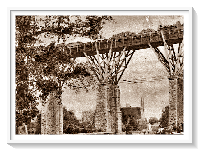
Next to the viaduct is the stump of a much older viaduct built from 1859 This would have had a wooden construction supporting the railway lines - see photo at end of the post. This proved to be a false economy so the current viaduct had to be built in 1899.

For the start of the walk, go under the viaduct and keep on walking in a straight(ish) direction until you see the signs shown below - then continue to keep walking in a straight direction.

You will pass a few old cottages on the right hand side.

Further on there are a couple of newish houses on the left. The one in my photo was once the local chapel. You can see the original window towards the right of the photo.

Keep walking and there is an abandoned building, on the left, once used within the china clay industry.

You will soon pass dog kennels on your left - the animals are all safely confined! Looking left after the kennels you'll see an old chimney - again once used in the china clay industry.

Keep walking in a straight direction along the lane.

Another house can be seen on the righthand side. I've always fancied this property.

They have an old signpost near the gate.

A small stream now follows, along the valley, on the right of the lane. The stream was once used for the panning of tin. Unfortunately my next two photos of the stream aren't too good as this was a blazing hot day. There were strong shadows and the water had virtually dried up.


On the left is a large building. Yes you guessed: once used in the china clay industry.

Carry on walking, passing a gate, which leads to a private area.


Keep walking and on the right you'll see the remnants of some china clay ovens.

The path is now quite straight for a while.

Ignore the track to the right and you will soon see ...

... a few old cottages.

You may also see the Public Footpath notice, but ignore this and keep walking in a straight direction

By doing this you'll come to a gateway. Pass through this - no climbing necessary!
The path becomes a lot narrower.
It looks brighter out of the shadows.

Back to shadows again!

Not to worry though as the path will soon lead to a road. At the road turn left. There is very little traffic. On my walk here I didn't see any vehicles - or meet any people!

From the lane there are pleasant views if you look to your left.

If it's a clear day you should be able to see the sea. The small tower in the far distance is Gribbin Head

Keep to the very left of the road and you should soon be able to see a Public Footpath sign as indicated below - which is a left turn from the road. Sometimes though, the sign is difficult to see.

The path doesn't really look like a public path as you will pass this house and a couple of other constructions. Keep to the left of the lane.

Pass by the side of the house as below.

It is now a case of following the path for quite a while.

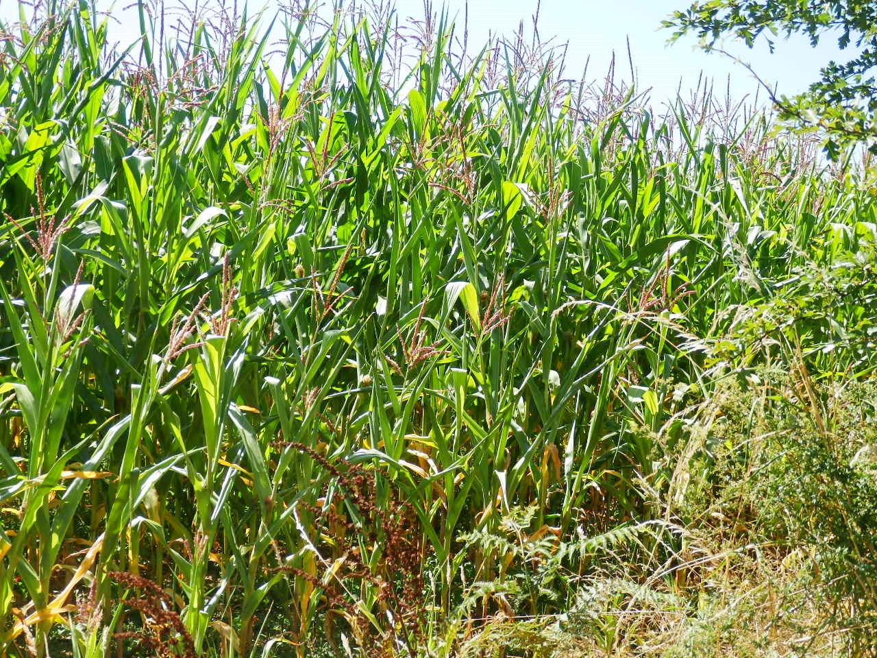
The views are dependent on what the farmer has done with his fields, in this case growing corn. Sometimes there are views to the right towards the sea.
Looking left, as below.

Another view of the path.

Okay we are now approaching a house so - as Dionne Warwick used to sing - Walk on By.

Unexpectedly we saw a Royal Mail van and he had to squeeze passed us. He wasn't a happy bunny as he grumpily bumped his way along the track.

Now we are coming to some civilisation. As soon as you reach the small housing estate walk down the immediate road going to the left (Trevanion Hill). It is quite narrow and goes downhill. Be careful, as it is often used by cars etc., especially if they are relying on a Sat Nav which, for some reason seems to think this is a short cut to several places.

Start to walk down the hill and on the right you'll see a wide gate where there are views over to the viaduct where the walk started.

The next two photos were taken from the road, so you can see from the views that it is quite steep.


Nearly all over now. At the bottom of the hill turn right and you'll soon be at the viaduct - where you started the walk.

As regards parking. There are usually several places to park a car in Gover Road. There is also a sort of small, untidy, lay-by just after the viaduct on the left.
I think that wraps up today's post, other than the photo below. This shows how the first viaduct would have looked with the wooden construction for the train lines. No wonder it was replaced by all stone.
That's all for today, thanks for visiting my blog. You are welcome to leave a comment below.
That's all for today, thanks for visiting my blog. You are welcome to leave a comment below.
All good wishes ~ Mike.

Thank you for taking me on this lovely walk, Mike. It looks delightful, and I could do it without burning a single calorie 😆
ReplyDeleteMy pleasure and glad you saved 800+ calories! It makes a change from most of the Cornwall walks along the coastal path overlooking the sea. China clay was once called white gold in Cornwall as it made so much money - only a shadow of itself no though. All good wishes.
DeleteInteresting walks you do Mike, great photos and story on your big hike. Love n hugs.x🤗
ReplyDeleteThank you kindly, glad you found the post of interest. Have a good weekend.
DeleteWhat an interesting and varied walk. The remnants of the china clay industry gradually being taken over by nature intrigues me. Super photo's and narrative Mike. 😊 🐕 🐢
ReplyDeleteThanks David, makes a change from walking by the coast. There is now a China Clay museum a few miles from the walk. Enjoy your weekend.
DeleteA very interesting walk Mike, and all the better for just seeing one royal mail van. How funny to stumble across old china clay ovens. I remember the fine viaduct well from a previous post of yours. Lulu x
ReplyDeleteThanks Lulu, the viaduct always fascinates me, I wonder how they built it without modern technology. I expect lives were lost. All good wishes.
DeleteA little historical context for you:
ReplyDeleteThe building in the 6th photo which you presumed to be china clay related, is actually a miniscule Bible Christian chapel, which was later replaced by the larger chapel in your 5th photo.
The house in the 9th photo is Treglyn, which has lovely gardens that are occasionally open to the public. You can find information by looking up Treglyn House on Facebook. In its grounds stands the china clay dry of Gover china clay works, which was further up the hillside.
The "building" in the 13th photo is actually more of a structure, and was part of the post-war mica residue capturing operation that operated here until 1967. The New Consolidated Mines Of Cornwall Co Ltd, run by Louis Mendels, was responsible for this, as well as the running of the two largest pits on the eastern side of the valley, known as Forest and Gover pits. In those days, mica was run off into the rivers as a waste product - however, containing small amounts of clay and fine silica sand, the waste was actually useful in pottery when dried. In the early days almost every clay works dried a considerable amount of their own mica to sell, but as the clay industry consolidated into fewer larger companies, they concerned themselves much less with mica, flushing ever more of it into the rivers for the more enterprising upstarts to process.
Your 16th photo looks into the "fire end" of the flues of one of the many china clay dries associated with Carne Stents china clay works just up the hill. The clay was dried on porous pan tiles heated by these flues, a method of working brought into the clayfields from the potteries of Stoke, whose introduction in Cornwall dates to 1845, and which continued, believe it or not, until 1992, at Carbis near roche, the clay dry that is now fancy apartments.
The 19th photo looks at the quaint facade of the remarkable No.4 Carne Stents. Although rather unassuming from the outside, this humble clay workers cottage is in fact almost completely original. In the roughly 150 years it stood here, it has never in its life been connected to electricity, water, or sewer. The original 12 pane sash windows still bear the wobbly horticultural glass panes they were most likely built with, and great wide floor boards still sit upon their original ceiling joists, scarcely 6 and a half feet above the floor level. The only "modern" upgrade, is that the old cast iron Cornish range was removed in favour of a series 1 Rayburn. The water-source for the dwelling is a spring just around the back, and the uh, "facilities" if you like, I'm told still consist of a bucket! Intriguingly, a separate second staircase at the back of the house would've been for use by a servant, a role once common in rural houses but now relatively forgotten. The staircase descends into the rearmost rooms, one of which would've been the scullery, and climbs into the loft space above, which would've served as incredibly modest sleeping quarters to say the least. Just downslope from No.4 on the same side of the unmade lane once stood a small engine house, and it was here on this spot that the great clay workers strike of 1913 began, an event immortalised by the 1972 film "Stockers Copper", well worth a watch if you haven't already.
The 33rd photo looks over across the valley toward Penisker, formerly Pyniscar, dating to 1327. This ancient farm settlement contains the ruins of the much older, previous farmhouse, which likely dates to the 1600s, notable for its immense kitchen chimney and miniscule upstairs windows.
The 39th and 40th photos look over at the chimney of Forest china clay dry, and in the 40th photo the waste heap of Forest pit is visible to the left. I am told that the resident of the white cottage on the right as you go up the valley is a former employee. This would've been tough work, as this old dry was never modernised, it worked the "old fashioned way" right to the bitter end.
I hope these notes give some interest and insight to the already fascinating and magical Gover valley. Best wishes, Scott Keane.