Wednesday 13 February 2019

Lostwithiel, Cornwall: Comparing How It Looked In 1908 With Today

1908 Vintage Photo of Lostwithiel
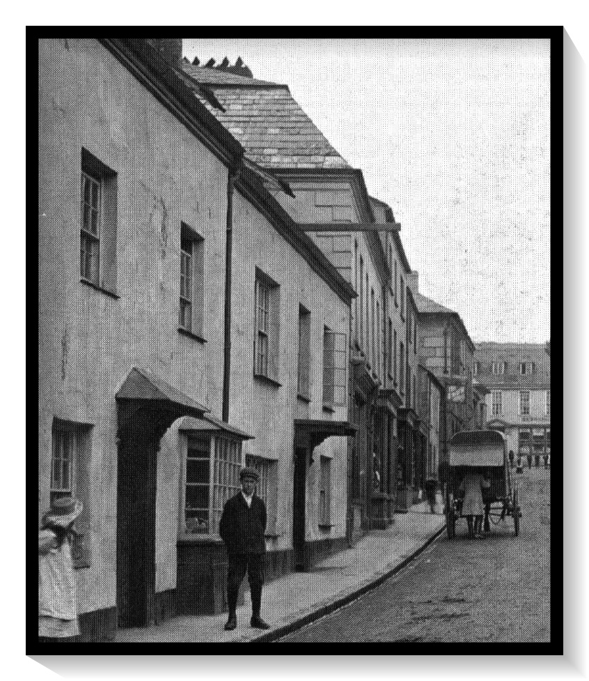
Lostwithiel, Cornwall circa 1908

Lostwithiel was once the capital of Cornwall. The name is derived from the Cornish Language word lostwydhyel which means a tail of a wooded area


While there I wanted to compare an old photo of the town with how it looks nowadays. But, oh dear, I forgot to take the old 1908 photo with me! 


I still clicked a few photos trying to remember the old photo. When I got home I compared my efforts and was quite pleased that my memory had served me reasonably well.


The photo above is from 1908 and below are photos I snapped. Though the angle is different I did manage to get the exact same buildings. The two houses on the left are now retail outlets, otherwise much is the same as it was - other than the people.

Lostwithiel, Cornwall
Lostwithiel, Cornwall Today
While in Lostwithiel we popped into St, Bartholomew's church. Difficult to take a photo as the spire is so tall and the streets are so narrow - so not a very good picture.
St Bartholomew's Church, Lostwithiel
At, Bartholomew's Church, Lostwithiel
The spire is made of Cornish Pentewan stone and was added in the 14th century. As for the clock, the heavy weights that drive it have to be wound up by hand every day.
Inside Lostwithiel Church
Inside St Bartholomew's Church, Lostwithiel

Other similar Posts: 

Tuesday 12 February 2019

The Green, Green Grass of St.Mewan: But For How Long?

Green fields at St.Mewan, Cornwall
Farmer's green fields in Cornwall
We were walking along the road to St.Mewan, Cornwall and remarked about how green the fields are. Most likely because of all of the rain we have had.
Green fields, St.Austell, Cornwall
Green fields with a china clay works in the background, St.Austell
Green fields with a wind turbine on the hill, Cornwall
After the green fields came St.Mewan church which dates back to Norman times. The bell tower foundations and the base of the font were built in 1100.
St. Mewan church, St.Mewan, Cornwall

Side entrance of St.Mewan church, St.Mewan, St.Austell, Cornwall

We carried on walking onto the main Truro to St.Austell road - the A390 ...

Road sign to St.Austell, Cornwall

... and then there was the sign below. It's been there for quite a while but somehow it really struck home. This will/may become 60 acres of houses and retail units. In other words yet another 60 acres of green fields will disappear forever.

This probably isn't the place to debate affordable housing, an increasing population, transport links, sewers, roads etc. But, whatever, it equates to green fields disappearing.


Large sign of houses to be built in Cornwall

The signs are there: The times, they are a-changin'.

Road sign to Bodmin, Liskeard and visitor attractions in Cornwall

Monday 11 February 2019

Polruan, Cornwall : Coastal Views, Chapel Ruins And A Castle

Approaching Polruan, Cornwallby ferry
Polruan and a Boat Yard
Today, photos of a visit to Polruan - and where I snapped the photo for this blog's heading.

We left our car in Fowey and then crossed the River Fowey to Polruan. The photo below is the first of Polruan. It's a small village with one road in and one road out.

Cottages in Polruan, Cornwall
Polruan
The Polruan road is quite steep but this allows lovely views across the Fowey river. That is, if you are okay walking backwards up a steep incline! The good thing is there aren't many cars about.
Looking across to Fowey from Polruan, Cornwall
Looking from Polruan across the river to Fowey
At the top of hill are wonderful views of the River Fowey - and a convenient seat!
Beautiful view of the Fowey River, Cornwall from Polruan
The River Fowey
At the top we find St. Saviours chapel - well the remains.

The chapel was partly destroyed following King Henry VIII's dissolution of the monasteries. It is said that local gentry removed the chapel bells for safe keeping - but the location is unknown. The chapel fell into disrepair from 1572.

Ruins of St. Saviours church, Polruan, Cornwall
Ruins of St.Saviour's Chapel
Alongside the chapel is a National Coastwatch Station, where visitors are welcome.
View of Polruan headland, Cornwall
Coastwatch Station and remains of St.Saviour's Chapel
A view from the top of St. Saviours Hill.
View from St.Saviour, Polruan, Cornwall of sea and cliffs
View across to the Gribbin Head
And, at last, the photo I took for this blog's heading :

Sea and Cliffs across from Polruan to Gribbin Head
Photo I used for this Blog's heading
After having had our fill of the views from St.Saviour's Hill we made our way back down to sea level and had a quick look at the remains of Polruan Castle.
Polruan Castle, Polruan, Cornwall
Polruan Castle
The castle is a Blockhouse and was erected in the 15th century for the defence of the harbour. It was linked by a large chain with a similar Blockhouse on the Fowey side of the river. The chain could be raised to stop unwanted ships entering the harbour - and was last used way back in 1666.
Inside Polruan Castle
So, it was then back to Fowey by the same small ferry boat. The photo below shows the view of arriving back in Fowey.
Fowey
Approaching Fowey

Sunday 10 February 2019

Looe, Cornwall On A Cloudy Day

Looe Beach, Cornwall
Yesterday's Post featured Polperro. Just along the coast is Looe. The photo was taken on a cloudy day, just before the rain arrived. But people still looked for treasures along the beach.

Saturday 9 February 2019

Walking The South West Coast Path Into Polperro, Cornwall

South West Coast Path near Polperro
A few photos walking the South West Coast Path and approaching the village of Polperro.
Walking on South West Coast Path, Cornwall
Lots of ups and downs as we walk the coastal path. In the photo below you can just see the top of the small Polperro lighthouse at Spy House Point. Built in 1911, it is only ten feet tall but the light can be seen for eight miles. There is a track down to the lighthouse.
Polperro lighthouse, Cornwall
The path gradually starts to go downhill.
South West Coast Path, Cornwall
Finally we reach the outskirts of Polperro - still downhill!
Path leading down to Polperro, Cornwall
At last, Polperro harbour and the tide is out. The old fishing village is like stepping back in time, with cottages clinging to the hillside - a great place to visit.
Polperro, Cornwall when the tide is out

Friday 8 February 2019

Par Sands : Photos of Beach and Surroundings

Grasses on the sand dunes at Par, Cornwall
Grasses on the sand dunes at Par
We were passing Par Beach - or Par Sands as it is now known - and decided to stop so I could snap a few photos. It's not my favourite beach by any means, but many years ago we owned a couple of caravans here which we let out to holiday makers. So, in a way, the visit was to see how the area has improved.

Golden grasses are still on the sand dunes. The beach is very flat and the tide goes out quite a long way, leaving seaweed and the like behind. To the nearside of the beach the scenery is very pleasant - and it's possible to walk along the cliffs for many miles.
Beach at Par, Cornwall
Par Beach, with the tide out
A few large rocks are on the far side of the beach but ...
Rocks on the beach at Par, Cornwall when the tide is out
Rocks on the beach
... unfortunately, also on the far side of the beach is a clay factory, though it is reasonably hidden.

China Clay works next to Par Beach, Cornwall
Clay works at the far end of the beach 
The beach is a favourite with dog walkers at this time of year.
Walking dogs on Par Beach, Cornwall
Dog walkers on the beach
There are many holiday caravans and a few chalets at the back of  the beach. All very neat and tidy - and far superior to the ones we used to let out. Times have changed, holidaymakers expect much more nowadays.

Holiday caravans at Par Beach, Cornwall
Caravans at Par Sands
Par Beach has it's own lake with geese, ducks, swans and other birds
Lake at Par Beach, Cornwall
Seagull on watch at the lake
Children enjoy feeding the ducks here, but the swans and geese can be a little overwhelming for small tots.
Ducks, geese and other birds at Par Beach lake
Geese, ducks and other birds at the lake
Chalets at Par are on the far side of the lake and some overlook the water, again all very neat and tidy.
Lake at Par Beach, Cornwall
Chalets at Par Sands

Thursday 7 February 2019

The Mysterious Creatures Guarding Helman Tor, Cornwall

Dinosaur style rock at Helman Tor, Cornwall
The granite dinosaur casts his eye over Bodmin Moor. He has a good vantage point as he silently observes from the top of Helman Tor. The views stretch for miles. On a clear day it is said that Cornwall's south and north coastlines can be seen.
View from top of Helman Tor, Cornwall
As well as the dinosaur there is a giant turtle or maybe a tortoise.
Rock that looks like a tortoise or turtle at Cornwall's Helman Tor
Okay, okay, a stretch of imagination perhaps, but there are many strange shapes created by the natural granite boulders on Helman Tor. It's fun to see where your imagination takes you.

The shapes and scenery have been viewed by man since Neolithic times - some 4000 years ago. A settlement was created here and homes erected from stones and rocks. Some of the later boundary walls can still be seen - they are there to be touched.

The prominence of the Tor in the landscape may have given the settlement a strategic position for ceremonial and economic functions - a place to meet, worship and trade.
Wild scenery at Helman Tor, Cornwall
Over the years the granite boulders and rocks have created such strange shapes and patterns on the landscape.
Granite rocks at Helman Tor, Cornwall
Huge granite rocks at Helman Tor, Cornwall
The weather can change quickly on the moors, as perhaps the photos illustrate - from bright blue to drab skies as the wind directions change.
Layered granite rocks at Helman Toe, Cornwall
The photo below shows the Helman Tor Logan Stone or Men Omborth in the Cornish language,

Logan stones are balance stones - they can sometimes be moved by hand despite their great weight. It is believed that Druids used these for their rites and rituals. Uneducated people would believe that the priests had magical powers as they moved such huge granite boulders without any effort.

Logan stone at Helman Tor, Cornwall
Helman Tor is away from the main Cornish tourist trail and is reached by driving or walking along very narrow roads - which are often single track. So, if driving you have to keep fingers crossed that nothing is coming in the opposite direction - as one of you will have to be good at reversing!

When visiting the Tor I have rarely seen any other people. Though on one occasion I did see many wild ponies at the top - which was quite magical.
Map showing Helman Tor

FEATURED POST

A Day in Cornwall: Charlestown, St.Austell, Heligan

A few photos from the last week when we were out and about. Above is the port at Charlestown and below is looking out to sea from the harbo...